
Day 10: Santo Domingo de la Calzada - Belorado
Distance: 23 km(14.3 miles)
Approximate Walking Time: 5-6 hours
Altitude: Start at 641 m(2,103 ft.) and slowly ascend up to 772 m(2,532 ft.).
 We left Santo Domingo around 6:30 a.m. The Camino followed the main street out of town. We came across some confused pilgrims and together, we had to play find the obscure yellow arrow in the dark. We found it across the road and followed the trail back into the hay fields. We went up and down and up and down until we arrived to Grañon around 8:00 a.m. As we approached the town, the sun started to break over the horizon and we turned around to watch it rise. Like dominoes, everyone behind us turned around and stood and watched it rise. One of the best things about walking the Camino was watching the sun rise every morning.

 Most of the town was up by the time we arrived. We decided to keep on walking instead of stopping to buy bread because we figured somewhere else along the way would have it. We were wrong. There were shops in Grañon and if you need a bite to eat, this is the last place to stop until you reach Belorado. Grañon's famous church is dedicated the St. John the Baptist and was built in the 15th or 16th century. Grañon has an interesting legend that goes like this: There was an oak grove that the residents of Grañon and Santo Domingo fought over. After many daily squabbles and fights, it was decided that each town would pick one fighter to fight in hand to hand combat to determine which town would get the rights to the grove. While the fighter from Santo Domingo chose to bath himself in oil so as to be impossible to grab, the people of Grañon chose a farm worker who ate lots of large red beans and was strong. When the two began to fight, the one from Grañon realized he couldn't grab the oil slick guy from Santo Domingo so he proceeded to insert one of his fingers in the rectum of his opponent, lifted him over his head, and threw him a great distance. Thus, the oak grove went to the town of Grañon.
 Grañon is the last town on the Camino in the region of La Rioja. Here, we entered the region of the longest stretch of the Camino, Castilla y León.

 The next town we passed through was Redecilla del Camino. It was famous along the Camino for having a Roman Baptismal Pool in the church. We didn't get a chance to see it because the church was still closed at 9:00 a.m. when we arrived. The town is over 1,000 years old and has a few buildings that date just before the beginning of the 11th century. The local store didn't have any bread because they were too lazy to bake it and have it ready at 9:00 a.m. How late the people in town sleep is a mystery because we only saw two construction workers outside when we passed through.

 We continued on and passed through more hay fields and the towns of Castildelgado and Viloria de Rioja. Both were small villages of 80 and 70 residents respectively. Both had nice houses but were full of flies and the ever pervasive smell of cow dung. How the residents have accustomed themselves to breathing air that reeks as bad as it did is beyond my comprehension. We stopped to take a short break but the constant irritation of swatting at flies and smelling cow patties inspired us to move on quicker than we wanted to.


 We passed through another town, Villamayor del Río, on our way to Belorado. The five kilometers after Villamayor were long and boring because the scenery didn't change much and the Camino followed the N-120. Lots of big trucks pulling cargo honked and waved as they drove by. There was always encouragement from people as we walked. We met a nice family from Colorado as we entered the city. The father had done the trail a few times and wanted to walk it one more time before he couldn't travel anymore. He had his wife and daughter with him. Entering Belorado was nice and relieving. There was an albergue that cost 5 euros right at the entrance to the town. It had something like 100 spaces but it was a full km outside of town and seemed quite impersonal. They used a swimming pool as a draw for pilgrims but there was another one in town with a pool also. We went on into town because we felt like we would stop for lunch and move on afterwards because the overcast day made it easier to walk.

 We stopped in the main square and made sandwiches. It was a great place to relax because there was a gazebo surrounded by lots of trees in the middle. Belorado had all of the conveniences we wanted, a full supermarket. We bought some bread and enjoyed some much needed rest. As we ate, the square filled with families and retirees out enjoying the nice weather. As we pondered moving on, a dark cloud began to form in the distance and we decided we should stay put for the night. Just around the corner from the main square, we found the albergue Cuatro Cantones. It cost 6 euros. It had the option of more private rooms, a pool, and a kitchen. The guy at the front desk was Brazilian and spoke four languages quite well. There was another albergue in town, El Caminante. It was 5 euros but didn't have a kitchen.
 The town was enjoyable. The buildings were mostly made of old stone and gave a real medieval feel. Just across the street from our albergue was one of the best murals of the Camino we would see. The town's origins were Celtic and later, the Romans moved in. The main church was Saint Mary's Church. It was built in the 16th century and had an amazing portal and nave. The town had a great museum on the main square dedicated to the Camino de Santiago and its history. We saw many signs that signaled the upcoming Onion Festival. It was to commence the next day and we were saddened by this. As we walked the Camino, we discovered that had we started one day later, we would have arrived just in time for many festivals in several of the towns along the way. Our dinner of hot dogs wasn't the best but it filled us up. Around 7:00 p.m., a strong thunderstorm blew through and made us glad we didn't continue on to the next town. We went to bed early but awoke often because of the pesky people in our room snoring loud and talking in their sleep. It was a long night.


Day 11: Belorado - Agés
Distance: 28 km(17.4 miles)
Approximate Walking Time: 7-8 hours
Altitude: Start at 772 m(2,532 ft.) and ascend up to 1,150 m(3,773 ft.) 3 km past Villafranca Montes de Oca and descend to 1,101 m(3,612 ft.).
 Izzy woke me up at 5:30 when the snorers reached an unbearable level. We packed and left quietly since we couldn't sleep any longer. We followed the path out of town and crossed the bridge over a small river. It was quite dark and the sky was covered in clouds so we couldn't see much except when the large trucks passed by and shined their lights. Just as we left the town, it started to rain. We spotted an office building near the road and crossed over to stand under its shelter until the rain passed. We waited about a half hour until the rain cleared out. The good thing about the Camino was that it didn't get overly muddy after the rain. We slowly ascended up to the first town of the day, Tosantos. It had an interesting church set against a large mountain back drop. Sadly, we couldn't get a great picture of it because of the lack of light at the time of day we passed by. From there, we headed on to Villambistia and Espinosa del Camino. All three villages only had 80 or so inhabitants and were dotted with old houses, old churches, and of course, the mandatory smells of farms and cows. Most places had at least one fountain of drinkable water in them. The general rule was that if there was no sign indicating non potable water, it was safe. That may not always be true. There was an albergue in Espinosa advertising a communal dinner.


 We stopped in Villafranca Montes de Oca because it was the largest of the small towns thus far. It had loads of cafes and bars to satisfy the demand of the truckers passing through to avoid the highway tolls. We found their supermarket, a cooler in a bar with the barest of selections. We sat on the bench in front of the municipal albergue (6 euros per night) and had some breakfast. We had thought of walking here the day before but the rain stopped us. It was a nice town and sat at the base(948 m(3,110 ft.)) of a large mountain. We wandered around the church and poked our head in for a quick peak. The town was founded by the Romans. Later, it was overrun and destroyed by the Moor Invasion. There were some caves near the towns bearing their name. After a bit of a break, we started our steep ascent.

 The rise out of town was steep and on terribly uneven ground. The view was breathtaking. We found an encouraging sign showing us that Santiago de Compostela was slowly getting closer. At the top of the mountain was a nice rest area where we found an old man listening to talk radio and flirting with any female pilgrim that walked past. The trail cut through forest and felt like the first few days all over again. As a tip, do ensure you have what you need when you leave Villafranca because the next stop is San Juan de Ortega, 12 km away.


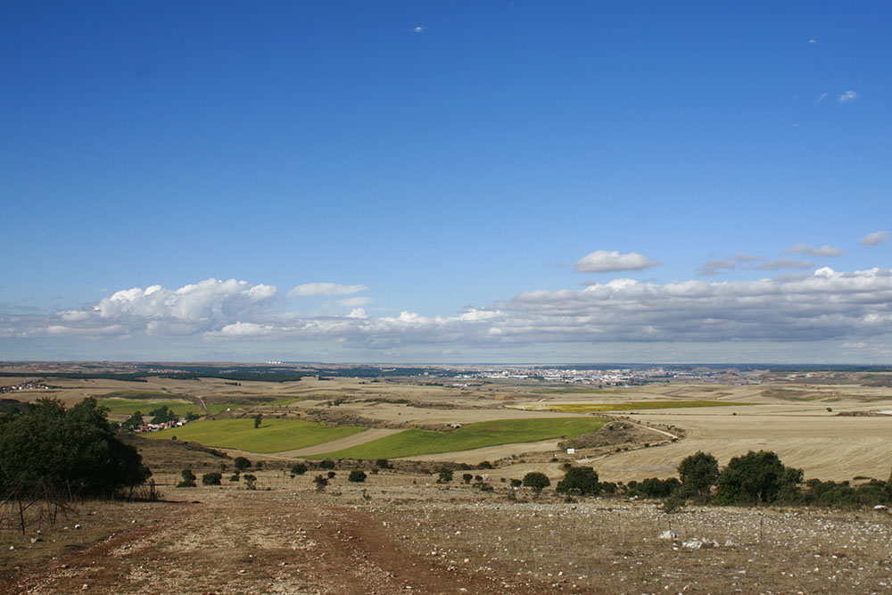
 We took the picture below to show how much you can descend and ascend in a typical day. This was one of the worst examples of how the trail dips into a small valley and then rises back up to the same height. Walking over stones all day was painful on the feet.


 After a long and sometimes muddy 12 km, we arrived to San Juan de Ortega. It was listed as a stopping point for the day on the French office suggestion list. We don't know why because there wasn't a whole lot to do there other than walk around the monastery and the church. There were only two albergues. One was private and the other was based out of the monastery. It was built by the town's namesake, San Juan and his devotion to helping pilgrims on their journey. He had the church and monastery built to provide a place of shelter to the pilgrims. They date back to his lifetime sometime in the 11th century. The modern day town itself didn't even register 30 inhabitants. The monastery and the church were nice but a thirty minute break was all we needed before moving on to Agés. The main reason we continued walking was to have more time the following day in Burgos.


 It was only another 4 km to Agés. Outside of San Juan, we found a sign telling us that we could continue on the traditional trail to Agés or take an alternate route that was greener. The word green in this sense means that you will bypass a lot of the industrial parts of Burgos along the traditional trail. Even though we found the sign, the new addition to the trail didn't seem to be open so we continued on to Agés.

 The town was small but lovely. We contemplated going on to Atapuerca but a quick call to the albergues there told us we should stay in Agés. The albergues in Atapuerca cost around 7 euros and they didn't have any type of kitchen. There was a loud mouth woman in Agés using the stereotypical sales pitch of how her place was the nicest on the whole Camino and she wasn't in the business of duping pilgrims, only trying to help them, blah, blah, blah. She had two buildings, one with a hostel style accommodation for 9 euros a night and a house around the corner with beds and a private bathroom for 5 euros a night. We chose the 5 euro beds. The downfall to Agés was that none of them had proper kitchens so we ate canned lentils and chickpeas heated in the microwave for dinner.

 The town had a lot of old buildings built from stone. The town dates back to the Roman times and the church was built in the 10th century. We walked around the town for a bit and made friends with some new faces we'd seen the past couple of days. We met one couple who'd hiked all the way across France from Straussbourg. They were incredible, patient people. They had been walking with a Belgian who started in Le Puy, France, just south of Lyon. They were the type of people that make the Camino very special. Since we didn't sleep well the night before, we went to bed early.


Day 12: Agés - Burgos
Distance: 24 km(15 miles)
Approximate Walking Time: 5-6 hours
Altitude: Start at 1101 m(3,612 ft.) and descend to 953 m(3,127 ft.) at Atapuerca, then back up to 1100 m(3,608 ft.) and then descend to 856 m(2,808 ft.) in Burgos.
 We left around 6:30 and walked on to Atapuerca. As we walked along the road between Agés and Atapuerca, we saw a large building alone in a field and a big sign advertising the yacimientos de Atapuerca. It turned out to be an archaeological site of recently discovered human remains predating any other remains of people thought to have lived in the Iberian peninsula. We wasted a couple of hours hanging out and waiting for the offices to open only to find out we needed a reservation and the trip out to the site would be three hours long. We left and headed through Atapuerca and started up the only mountain we would have to cross for the day.

 The ascent was steep, rocky and bordered by a military zone. The fencing the military used to keep trespassers out was a bit of a joke. It consisted of loosely laid barbed wire that almost anyone could just walk through with a couple of easy bending motions. The only thing that alerted us to the military nature of the land was the occasional sign telling us to keep out. The trail was so rocky that the bikers had to walk up instead of riding. We saw a baby snake cross the path. It would be the first and last we saw during the entire hike. At the top, we found a large open meadow covered with rocks and a beautiful view of the valley below and Burgos.


 The path to Burgos was anything but direct and wound through the small villages of Cardeñuela Riopico, Orbaneja Riopico, and Villafría. Most of them were small farming communities or people who didn't want to live in the hustle and bustle of a bigger city. Occasionally, we passed large fields full of blooming sunflowers. For the most part, the trail consisted of walking on a boring, paved road. After we walked through the last town, we crossed the highway, walked around the airport, and into the outer edge of Burgos. We took the recommendation of catching the bus into the city center from a pilgrim who had walked the trail several times. We made the decision based on losing the two hours waiting in Atapuerca waiting for the office to open and tell us we had no chance of seeing the site. I felt bad but we wanted time to walk around Burgos and run some errands.
 The Camino went past the north side of the Cathedral and the municipal albergue was just before it. It was a huge building with 140 beds spread throughout six floors. The layout was nice. There were four bed cubbies with divided walls. We were lucky and they put us against the wall. Our cubby had two beds instead of four. It cost 5 euros and had great information about the rest of the albergues in the Burgos province. This helped us determine how far we were willing to walk the next few days. There was no kitchen so we had to eat at a restaurant. This didn't bother us though because we had planned to dine with a guy from Brussels we met in Agés.

 There have been people in the region of Burgos since the Iron Age. It's a well established region and took its formal name of Burgos sometime in the late 9th century. It has all of the conveniences of a major city and most people on the Camino choose to stay an extra day to see the town. For many of the Spanish people we met, Burgos would be the end of this year's hike and the starting point for the next year. It's quite common for Spanish people to the do the Camino 10-12 days at a time as most don't have the vacation time to do the entire thing at once. If they do, most don't want to spend their entire year's vacation hiking. We didn't have that luxury so we spent the day walking around.
 We visited the famous Cathedral. It cost 2.50 euros for pilgrims to get in. It was started in the early 13th century and built under the strictest of French gothic standards. The main entrance was designed to incorporate the Portal to Saint Mary, the namesake of the church. The main chapel was elaborately decorated with gold and sculptures of famous biblical scenes. The tomb of the famous figure El Cid and his wife, Doña Jimena were between the main Chapel and the choir. The organ and choir area were amazing. The wood carved chairs and the organ pipes surrounded by amazing sculptures were remarkable. There were 14-15 chapels scattered throughout the Church. Each one was dedicated to a Saint or famous biblical figure and elaborately decorated. There was a museum full of various artifacts from the church and to leave, we went down to the crypt and basement levels of the church. As we left, it hit me just how intricate the building really was.


 For the rest of the day, we walked around Burgos. There was a river running through the heart of the city and a tree lined road to provide lots of shade from the sun. We took advantage of being in a big city and caught the bus in front of the Royal Theater out to the Decathlon. It's the Spanish version of a sports shop. We bought some new trekking socks and a new shirt. We also went to the supermarket across the parking lot to resupply ourselves with sandwich meat and some snacks. There was a free Hipercor bus that took us from the Theater out to the Hipercor and Decathlon. We had dinner on the square out front of the Cathedral. It's hard to make a recommendation of a place to eat as most of the places in Burgos offer delicious food as part of their Pilgrim Special.


Distance: 23 km(14.3 miles)
Approximate Walking Time: 5-6 hours
Altitude: Start at 641 m(2,103 ft.) and slowly ascend up to 772 m(2,532 ft.).


Day 11: Belorado - Agés
Distance: 28 km(17.4 miles)
Approximate Walking Time: 7-8 hours
Altitude: Start at 772 m(2,532 ft.) and ascend up to 1,150 m(3,773 ft.) 3 km past Villafranca Montes de Oca and descend to 1,101 m(3,612 ft.).


Day 12: Agés - Burgos
Distance: 24 km(15 miles)
Approximate Walking Time: 5-6 hours
Altitude: Start at 1101 m(3,612 ft.) and descend to 953 m(3,127 ft.) at Atapuerca, then back up to 1100 m(3,608 ft.) and then descend to 856 m(2,808 ft.) in Burgos.


No comments:
Post a Comment